The Landscape in Plain Terms
Where Mt. Baker sits, how to reach it, and what the corridor actually looks like.
Location
Mt. Baker is a glaciated stratovolcano in Whatcom County, Washington, located approximately 56 miles east of Bellingham and roughly 90 miles north of Seattle. It is the third-highest peak in Washington state and, at 10,781 feet, is the northernmost active volcano in the contiguous United States. The mountain sits within Mt. Baker-Snoqualmie National Forest and is bordered to the east by North Cascades National Park.
The town of Glacier, the last significant community before the mountain, sits at approximately 1,000 feet elevation along Highway 542. It is small: a handful of restaurants, a general store, cabins along the river, the pulse of a working mountain community. Maple Falls is eight miles west, Bellingham an hour beyond that. Vancouver, British Columbia, is roughly ninety minutes northwest, making Mt. Baker genuinely accessible for Canadian couples.
Getting Here
The closest major airport is Seattle-Tacoma International Airport, approximately two to two and a half hours south depending on traffic. Bellingham International Airport is smaller and approximately ninety minutes west of Glacier. There is no public transportation to Glacier or up the highway. All guests require a car.
Check current road conditions, including the seasonal closure of the last 2.7 miles to Artist Point, through the Washington Department of Transportation Mt. Baker pass page.
The Drive Itself
Highway 542, the Mt. Baker Scenic Byway, begins in Bellingham and ends at Artist Point. The drive from Glacier to Artist Point, approximately 25 miles, passes through old-growth cedar and hemlock forest, over the North Fork Nooksack River, past Nooksack Falls, through the ski area, and into the alpine terrain of Heather Meadows. Every serious guide to Mt. Baker weddings mentions the drive. We will say it again: encourage your guests to leave time for it, pull over at Silver Lake if the light is right, stop for coffee in Glacier before continuing up. The approach to the mountain is not neutral. It prepares people for what is coming.
The Two Mountains
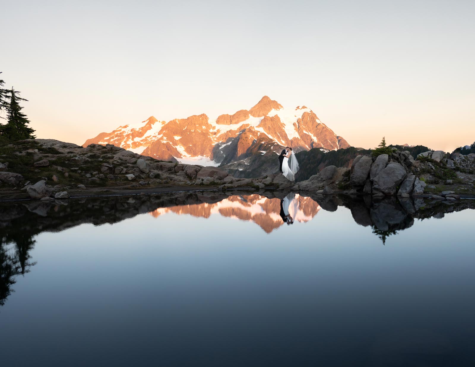
Mt. Baker. The glacier-capped stratovolcano. The primary peak visible from the west, the ski area, and Artist Point. At 10,781 feet, it anchors nearly every wide-angle photograph taken in the corridor. The summit is permanently ice-covered and includes Sherman Crater, an active volcanic feature.
Mt. Shuksan. Named from the Lummi word meaning high peak. Located just east of Baker, Shuksan’s jagged ridgelines and multi-faceted glaciers produce a visually different kind of drama from Baker’s smooth volcanic dome. From Artist Point and Picture Lake, both mountains are visible. At golden hour, Shuksan’s north face glows. It is the peak that stops people mid-sentence.
Key Locations Along the Corridor
- Nooksack Falls: 88-foot waterfall, short walk from parking, accessible year-round
- Picture Lake: Classic Mt. Shuksan reflection shot, accessible July through October plus year-round from the lower road, wheelchair accessible
- Bagley Lakes: Gentle walking, alpine lake access, accessible most of the year from the ski area road
- Heather Meadows: Visitor area, wildflower meadows in summer, accessible July through October
- Artist Point: End of the highway, 5,140 feet, panoramic views of Baker and Shuksan, accessible by car mid-July through mid-October
- Chain Lakes Loop: 7-mile trail from Artist Point through a series of alpine lakes, accessible in summer and early fall
- Winchester Mountain Lookout: Historic fire lookout, 4-mile round trip hike with summit views, accessible summer through fall
The approach to the mountain is not neutral. It prepares people for what is coming.
Next Step
Want help choosing the right corridor location?
Our local knowledge is what we offer that no photographer guide can replicate.